Many National parks have a maximum number of days you can camp in one site, so to beat the system, so to speak, all you need to do is wait for the campers to leave and just reserve their site and move over. It's a bit of a hassle to move a fully set up campsite like mine as I had a lot of tarps that enclosed the area under my tarp attached to my camper. The side curtains were retractable so at night I could pull them closed and take my shower right in front of my door. I sat my 7-gallon solar shower bag sat on the back corner of the camper top before I raised it up. This gave me a week of showers with water to spare
It's 6:00 am, August of 2002, and most any minute now the crisp cool Utah air will lose its chill as the morning sun begins its ascent and bathes my subject in beautiful rich warm lighting. My subject before me this morning is the Twin Towers of Hovenweep, an ancient Anasazi Indian ruin that is quite possibly well over 900 years old. The early morning lighting is almost covering the ruin as I peer through the viewfinder of my camera sitting on the tripod. Just as I’m about to trip the shuttle release cable and make the exposure, I hear the haunting wailing sounds of Ancient Indian chanting behind me, cutting through the still crisp early morning air. It seems as though I have been photographing all of my life, even though it has only been about the last 30 years or so. Perhaps that is attributed to my natural photographic eye. I have always admired the natural beauty of Florida’s vast sweeping landscapes, the pristine waterways, and lakes throughout the southern and central parts of the state as a kid growing up there.
As a true “Florida Cracker”, I have enjoyed the outdoors all my life. Having been well versed as an avid skin and scuba diver, aquarist, hunter, camper, boater, and fisherman, these hobbies have instilled a deep-rooted appreciation for all of the aspects of these outdoor activities. I guess it comes as no wonder that my appreciation for the visual arts medium has come full circle for the last 30 years. Photography to me is a way of life, a means of being able to continue seeking new places to explore and most importantly, to photograph it and meet new friends. A good friend once said, "There is no such thing as a stranger...they are only friends I have yet to meet. In the summer of 2002, I had the wonderful opportunity to spend three months out west camping and photographing in the southeastern areas of Colorado, known as the Four Corners Region. I began my trip camping in the Rocky Mountain National Park for a couple of weeks in May, then moving southwest into Utah for several more weeks in both sections of Canyonlands and in Arches National Parks.


The next destination was Moab Utah, and Canyonlands and Arches National Parks. My first stop was Canyonlands, "Island in the Sky" region, and photograph there for about a week. The highlight of this section of the park was photographing Mesa Arch at first light. I obtained many more beautiful images in and around my campsite location. Since camping in many National Parks is on a first-come basis, I have learned a nifty trick of driving to my next location the day before and securing my next site. The cost of one night is well worth getting there and finding out that all of the camp sights are filled up.
The Island in the Sky had many wonderful overlooks from which to photograph breathtaking landscapes. The image above was my view from the shade of the camper's awning. You really didn't have to do a lot of hiking, although there were some photo opts that required hiking to... I did not do any long-range hiking, only minimal shorter hike. I spent about a week here and no doubt could have spent another week for sure. While driving into town I came across a very unusual piece of Yard Art. I titled it "Indian Territory". Somebody had a weird sense of humor and a lot of work to make up this piece of art. The only that I encountered on this entire summer's trip was keeping ice for more than 2 days at a time. I had several types of coolers, but heat is heat, anyway you look at it. I tried dry ice wrapped in paper next to a block of ice, which helped some but still... It's just plain hot at that time of the year. It's generally a long drive into town to get supplies, more ice, and fill up the truck with gas. So you try to make the most of town trips just to not waste gas. Needless to say, I also load up on as much block ice as I can deal with at.
I saw a lot of passengers of those 4WD vehicles get out and not dive down that slope.Something missing here about Elephant Hill...see if it is in the original write up The backcountry of this area of Canyonlands had a lot of arches that required a 4WD vehicle and permit to get to. I made many panoramic images in this section of
 Canyonlands. I also did more hiking this section of this park, mainly to get to where I could photograph the Needles formations. Unfortunately, the Needles panoramic image is much too large for this layout. So I have a much compressed version showing the beginning of the formations. I missed out on knowing about a better overlook of these formations off the main highway turnoff just outside of Moab. I also had some unusual cloud formations one evening for a sunset and a morning where a sand storm came up all of a sudden and I had to hunker down behind some large boulders.When I got back to my camper, which was shut up as tight as zippered windows will allow, I found about a 1/4" of dust on everything in the camper. I had to take a lot of bedding and clothes into town to get washed.
 The hike into the area of this formation called "TheNeedles" was a long hike for me, but I enjoyed it. I started out at first light and took my time hiking, stopping for frequent water stops, and to sit on a rock and give my legs and back a -needed rest. When your body is as busted up as mine is, it's a total wonder that I am able to do things that I did back then. Today as I am rewriting this story, it would be totally out of the questions... not at age 76. I was 57 back then and quit was not in my vocabulary. The panoramic version of this image was much to large for this format, so I have shown only the beginning of this formation. So when I get bored making the big picture images, I begin to look for the small picture, often using the telephoto lens to get in close. I always try to play the light subject against the dark background which provides for a better image in my opinion. I must have made a dozen or so like images in this section of the "Needled"
One of the things I found interesting when I first came out to this part of the country was the magenta cast on the distant horizon. This was very evident at dusk and dawn at angles of lighting. When I looked closer at the sand, it was pinkish in color and very fine. It didn't take very much in the way of a breeze to elevate this fine sand into the atmosphere, thus the magenta color. Obviously, when you look at the various sandstone colors that make the beautiful formations here in this desert southwest, you can see that when the ocean waters receded and Mother Nature went to work out here, and the result was this beautiful pink sand.
My next location was Arches National Park where I stayed for another week. Even though you can come away with thousands of images from just driving around and stopping at all of the major icons of these parks, you can probably double that by hiking. However at this time of the year, mid-summer, it gets very hot, very quick. So plan on getting out bright and early and staying late, which is always the best lighting for photography in general, as well as fewer people to contend with.
I found the images I was able to make here were of breathtaking landscape formations. Broken Arch as seen here was right behind where I was camping with a short hike. However, in contrast, the hike up to Delicate Arch for me was quite a bit harder, but once I made it up there to this arch is was indeed massive in its size. This park does not have any shortages of Arches and iconic sandstone formations. I could only venture to guess how beautiful this place would be in the winter with the snow on the ground. Just the thought that it took over 100 million years or erosions by for Mother Nature to carve out these features that we are blessed to see today. Interestingly one of the major elements at work here is the salt deposits left by the receding ocean that once covered this area some 300 million years ago. It was these deposits that were responsible for much of the erosion of the sandstone layers of sediment once they were subject to wind and rain.


After leaving Arches NP I headed to Natural Bridges National Monument. This was a last-minute side trip to Natural Bridges NM and this is where I found an infatuation in photographing one of the Park’s ancient Indian sites, Horsecollar Ruins. I arrived at the high canyon overlook very early that still calm morning to take advantage of the warm color lighting. As I began photographing the
ruins, I suddenly felt an unexplainable eerie presence. There were no other people around that early in the morning, just me! But I felt that something or someone was indeed present here with me. Having quickly passed that off as merely the effects of the cool morning air, a welcomed slight breeze appeared and I returned to the task of photographing the Indian ruins. I then began looking a bit closer at these ruins before me, wondering what it would have been like living in such a small village as what these ruins represented. One of the interesting bits of information about this ruin is that it was most likely inhabited by two different tribes of Anasazi Indians thought to have inhabited this site between A.D.1050 and A.D.1300.
THIS ADVENTURE STORY IS BEING REVISED AT THIS TIME... STAY TUNED
There were found two distinctive shaped Kivas, which are ceremonial chambers used for religious rites, at this site. The round kivas were thought to be used by the Mesa Verde Anasazi of Southwestern Colorado while the square kivas were indicative of the Kayenta Anasazi of Northern Arizona. Pottery found at this site reflects these different influences, indicating likely trading between the two tribes. Horsecollar Ruins exhibits strong Kayenta traditions during the early period of occupation, with the Mesa Verde influence dominating the later period of use.
I moved on to the other iconic locations of the land bridges in this park. It is interesting to think of the differences between an arch and a land bridge. Arches are formed by wind and rain over millions of years after the great sea resided that covered over the Colorado Plateau. Land bridges however are formed by water alone. This water starts off as a small stream that goes underground at some point only to emerge somewhere else. Over a period of again, millions of years, the small stream gives way to a larger water stream or river that gradually erodes the rock into a land bridge. Multiple S-shaped curves in the river erode at different rates and the river eventually breaks through the narrowest of the bends and the bridge begins to form. The rest is only up to time.
The land bridges here in Natural Bridges are named Owachomo, Sipapu, and Kachina, and are named after the Hopi Indians. Owachomo means "rock mound", Sipapu means "the place of emergence" an entryway by which the Hopi believed their ancestors came into this world, and Kachina is named for the rock art symbols on the bridge commonly used on kachina dolls. To give you some perspective of their sizes;
Owachomo is 106 ft high from the river bed floor to the top, and spans 180 ft in length, is 27 ft. wide across the top, and is 9 ft thick at its base.
Sipapu is 220 ft. high from the river bed floor to the top, and spans 268 ft in length, is 31 ft. wide across the top, and is 53 ft. thick at its base
Kachina is 210 ft high from the river bed floor to the top, and spans 204 ft length, is 44 ft wide across the top and is 93 ft. thick at its base. You would generally have to go in person to see these massive icons, as my photos do not really show them their massiveness.

I was lying down late one afternoon and looked out my camper bed window and saw this very large Harvest, Full Moon. I kept thinking about where could I go to be able to photograph this beautiful sunset in this park and there was really no location that afforded a sunset view. After looking at the maps I saw an area called "The valley of the gods" and set out the next afternoon early to be able to find a nice foreground to go with that moon. Well, the ride down this steep winding loose gravel road was a bit daunting, to say the least, but I finally made it down to the valley floor. To my amazement when beginning my drive-thru this valley is that it looked like a miniature version of Monument Valley. This place was beginning to look really good. I could have spent several days in this place if I had the extra time. And you would have thought that I had all the time in the world but I did need to get to some other places that were on a schedule of sorts even though it was a month or so away.
The "valley of the gods" had very good dirt roads during this part of the dry season, as the rains were still a few months away. There were many places where you could pull off and park your camper. So this would allow for a more efficient fuel wise to be able to drive all the way through and then return back again for different lighting conditions.
Check the weather beforehand because some areas can become flooded after rain and will be a difficult mud crossing. This 17-mile road can be driven in either direction. One entrance is off Highway 163, 15 miles west of Bluff and 7 miles east of Mexican Hat, and the other entrance is off Highway 261, 10 miles northeast of Mexican Hat. Just type in "Valley of the gods, Utah" in your browser, and a host of information can be found about this beautiful area.
My next location for camping and photographing was at Capital Reef National Park in Utah. This was a really beautiful park with a ton of places to go for day trips or short overnighters into the backcountry. When I first arrived here I was amazed at the campground with the huge trees. This was the only campground that had what I call full shade. It was noticeably much cooler, maybe due to a small stream that ran through the park. As I was getting my camper set up I noticed that the hummingbirds were inside my camper, due in part to the bright red cooler. Once I set up a feeder they all left and the show was on. There must have been 100 hummingbirds trying to get at that feeder. The fighting and sounds of those little guys were amazing, to say the least.
One of the main icons of this park is "The Castle". I captured this by getting down into a roadside wash (ditch) so that I could obtain a better foreground. My personal motto when photographing landscapes is to look for Near Foreground, Middle Ground, and Background. This technique doesn't always present itself but when it does, the image is much better compositionally.

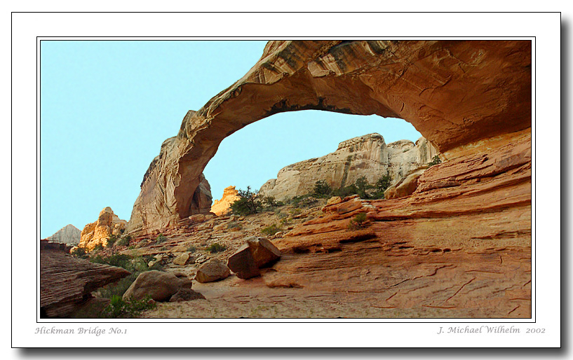
I only did minimal hiking here as most of the iconic formations, you were able to drive to. I did hike into the "Narrows" from highway 24 to about halfway. Interesting rock wall formations abound here. The next hike was to Hickman which was a bit more stressful for me. I did a long full day loop into the "Waterpocket Fold" and Strike Valley along the east side of the park. I crossed over at the Burr Trail Switchbacks, then over to highway 12 and back to camp. The drive back through the pine forest reminded me of Colorado. It was cool and refreshing to an otherwise hot day.

Once again, having a 4WD would have served me better, however, the ole white ghost did very well, all things considered. I extended my stay there by another 5 days over the week that I had planned because I met a couple from California that camped across from me. He was having fuel problems in his jeep and had to drop the fuel tank to replace the fuel pump. Once done he was ready to explore and invited me to tag along. This was great because if I did get stuck somewhere, he would be there to pull me out. This extended my range of locations and photography. If I would have had a 4WD, and some cooler weather I would have overstayed my welcome there for sure.
The one day that I did a tag along with my new found friend from California, we went into the backcountry of the South Desert, Middle Desert, and Cathedral Valley. We crossed thru the area called the Bentonite Hills. My friend said you don't want to come through here if it is raining, as this material is sticky clay...a thought for later. We made it to the Upper Cathedral Valley Overlook where the high road drops down in the valley and the road through the Middle Desert has deep sand and that my truck would not make it through there. So my friend said you made it here you should have no problem is going back the same way. So as I was photographing the overlook, it began to cloud up, and then a light rain began to fall. Remember that part about the "sticky clay" and "rain"? Well, my thoughts turned quickly to I need to "dee dee" out of here and get back through that area before it rains very much. I made it with no problem, even making that river crossing twice at River ford. There were some iconic features out in the Middle Valley that I would have loved to photograph, especially with the thought in mind of the Milky Way being part of those images.
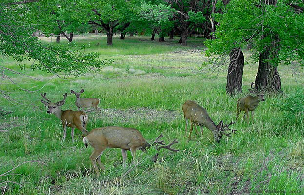
This park did have an assortment of wildlife to photograph Mule Deer, Yellow-Bellied Marmonts, Chuckers, and of course Hummingbirds. I'm sure there were many more species that I missed but these were what I found abundant. The Mule deer were in velvet at this time of the year and assembled in larger groups. The Chuckers had little one running around and the Marmonts, well they were fat and lazy.
When you think of it, as this story's afterthought, I could spend a lifetime out here in this park and the surrounding area alone and probably still not photograph everything. It's just one of those things that... 'you just can't get there from here'.
Now here is where I need to go back a bit to Natural Bridges NM because this is where I became infatuated with the Indian culture that inhabited this general area some 800-1000 years ago.


I believe that the events of the last two days were responsible for my sudden thirst for wanting to see more of these ancient ruins and learn about the culture of the Anasazi Indians. I changed my intended plans of where I was going to go next for camping and photographing. This included a side trip to Mesa Verde National Park in eastern Colorado. However, I managed to make a day trip to a preserved historic Anasazi site and museum in Blanding Utah as well as photograph two other alcove type ruin sites.
The Butler Wash Ruins was quite a distance and across a canyon to photograph, not up close and personal, as was the Mule Canyon site. There is something very magical about being able to be close enough to reach out and touch the nearly thousand-year-old stonework of these ancient people.
After arriving at Mesa Verde National Park in late July, I found that a majority of the park was closed due to the threat of sudden lightning strikes. These strikes have caused fires to break out at a minute's notice. There had been a fire a couple of years ago on Wetherill Mesa which burned across the top of the mesa and down to the Step House Ruin but did not do any damage to the site. Chapin Mesa was the part of the Park that was closed off. This area contained the vast majority of the many truly magnificent ruins within Mesa Verde. There was however one ruin within the closed area that I was able to get a ranger lead tour to, which was Spruce Tree House. This ruin was truly worth the hassle of having to take the bus and a ranger-guided tour in which to see this site. We were the first tour of the morning and therefore not having to deal with a great number of people, other than our group, was a serious photographer’s gift. This site is very large in its overall size, some three stories high by today’s standards, and yet much smaller than many of the other sites within Chapin Mesa. A portion of my group and myself climbed down into one of the below-ground sacred ceremonial chambers called a Kiva. This was a covered top kiva that was quite large and deep. There were about 15 of us that went down inside and there was room for more. This was another one of those eerie experiences that kind of raised the hairs on the back of your neck. To think that this once was an ancient Anasazi Indian religious ceremonial chamber that appeared to me to be just as it was back around 1200 A.D.
There were several other Mesas located in the Mesa Verde NP, which most of all are off-limits to the public. The park service personnel are still rebuilding and stabilizing many more ruins and hopefully, in the future, more sites will be available to the public to view. Within the Weatherill Mesa, I was able to photograph some of it from the high overlooks. There were 2 ruins, Kodak House and Long House which had ranger lead tours. Since I selected late afternoon light for these sites, I scheduled myself for two ranger-guided tours but was unable to do them due to lightning strikes that started fires. These small fires closed the tours and that section of the park each afternoon for the remainder of my trip there. Summer is not the best time of year to visit Mesa Verde. Still, with what was left to photograph, I could have perhaps stayed another few days to capture more images in the areas where you could drive and hike.
Wanting to see more Anasazi Indian ruins, I found a site called Hovenweep National Monument that was west of Mesa Verde and located in Utah, as well as a few other ruins located in southwestern Colorado that were close to Hovenweep. Here at Hovenweep, I found a treasure trove of photographic possibilities. This was the place of my opening paragraph on the third morning photographing the Twin Towers in “Little Ruin Canyon”. “Little Ruin Canyon” has about 10 ancient ruins. All 10 sites are within respectable distances from your camera position providing for exceptionally great images given the right lighting conditions. The rim trail around Little Ruin Canyon is approximately 2 miles covering many angles of each of the ruins. The ruins of Hovenweep and other ruins in the area are not preserved, nor are they as large as those found in Mesa Verde. Many of these ruins were constructed on top of very large boulders and high up on the rim of the canyons. This is perhaps why preservation of these ruins is fruitless, as Mother Nature, erosion, and gravity are constantly shifting the sand under these boulders, causing them to slide down into the canyon bottoms along with sections of the Indian ruins. The sloping canyon walls are littered with building stones of these ruins.
Since I was camping in the Hovenweep campground, I was afforded 7 days of photography there and at several other ruins within easy traveling distance from the Park. The rich history here is well documented in many publications, one of which is “The Towers of Hovenweep”, by Ian Thompson. The more that I read of this ancient Indian culture, the more in tune I was in my photographing these ancient ruins. Hovenweep is a Paiute Indian word for “deserted valley”.
Many strange events occurred to me while photographing here in Hovenweep, such as in my opening paragraph at the beginning of this article. The Indian chanting turned out to be a tape recording of an actual Navajo Indian medicine man played by his grandson each morning before he started work at the Park. Of course, I did not realize this that morning that I heard it. To say that the hairs on the back of my neck stood out like a porcupine is an understatement. Just think of the timing and location of this event.
I attempted many late afternoon lighting photo sessions at Hovenweep’s Castle, most of which made for some great sunsets. I was afforded only one afternoon with perfect lighting. Most afternoons the lighting was covered up by large thunderstorms. On one such attempt and after making several sunset images of the Castle, I was walking back to my truck along the darken trail, when I felt the presence of someone or something following behind me. After several stops, backchecking my trail, and seeing nothing, I continued on to my truck. The next morning, on the very same trail back out to the Castle I found large cat tracks in the sand following in the same direction as my footprints the night before. I confirmed my findings with the park personnel and that there were indeed large mountain lions in the area.
On another early morning photo session, my camera was set up on a ruin in the Holley Group of ancient ruins located just outside Hovenweep Park. As I was waiting for just the right lighting conditions to occur, I was once again distracted by what I thought was someone or something behind my location. It’s one of those moments that we all have had, but for me, they were becoming very frequent. I turned around looking back at the morning sun to see if there was anything there. Upon seeing that I was indeed alone, I turned back around to my camera, and there to my total amazement a rainbow suddenly appeared. Seemingly out of nowhere and within a matter of seconds, this rainbow appeared arching over and landing right next to my subject. Once again, the ole hairs on the back of my neck stood out, but I was awarded a wonderful image that will stay forever in my memory.
These memories and moments in time shall forever move forward in my thoughts, as I reminisce some of my most memorial times photographing out west, especially the fascinating Anasazi Indian culture. As I sit here in my camper writing the outline of this article, I’m listening to “Spiritland”, Musical Visions from the Southwest by John Huling, one of 3 musical CDs of Ancient American flutes combined with present-day musical instruments.
On my last evening at Hovenweep, I pondered some about these strange events that occurred to me while photographing these ancient ruins. Were these events some kind of an omen, and if so, what is to become of it? That night I made myself a solemn promise to once again return to the Four Corners Region and see what’s in store for me the next time.
As I sit here in my camper, playing these musical CD’s, listening to the sounds of the American Southwest Indian flutes, and sipping a cup of coffee, I am contemplating the next morning’s photo session in the “Land of the Ancient Ones, The Anasazi.”


